
Haor Statestics
OVERVIEW
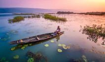
Bishwambarpur, where the waterline blends with the high green hills of Meghalaya, is visited by almost 30 kinds of migratory wild ducks every year. You can easily hire a dinghy from the local villages and enjoy the scenic, feathery beauty
Ongoing project
"Comprehensive Feasibility Study for Sustainable Restoration and Protection of Wetlands" as delegated procurement under the investment project titled "Re-excavation of small rivers, canals and reservoirs within 64 districts (1st stage) (1st revised)" under Bangladesh Water Development Board. Haor, Baor, Beel and connected rivers etc) in Different Hydrological Regions of Bangladesh”- titled survey work is being implemented by Directorate of Bangladesh Haor and Wetland Development. 81 special rivers of the country (whose origin is from a wetland) are being fully identified under this survey which is being implemented during the period of July 2019-December 2021. It will be possible to improve the quality of life of the people of these areas by taking projects related to the expansion of irrigation and increase in fish production through the excavation and maintenance of these rivers and wetlands.

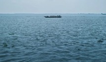
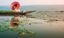
Tangua is one of the finest places in the world to enjoy the perfect sunset and the sunrise.
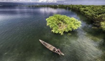
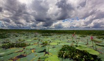
Tanguar Haor, located in the Dharmapasha and Tahirpur upazilas of Sunamganj District in Bangladesh, is a unique wetland ecosystem of national importance and has come into international focus. The area of Tanguar Haor including 46 villages within the haor is about 100 square kilometres of which 2,802.36 ha² is wetland.
Tanguar Haor is a river basin which is located at the Tahirpur Upazila of Sunamgonj district in Sylhet Division. Its takes roughly 6-7 hours to reach here from Dhaka. After getting off at the Surma Bridge just off the Bus station, you need to hire a bike or a CNG Taxi to get yourself at Tahirpur. From Tahirpur you can hire boat and enjoy the beauty of Haor.

Planning Process
Primary data have been collected through survey carried out during PCMs and RRA. Remote Sensing images have been processed and analyzed using GIS techniques. Secondary data have been obtained from National Water Resources Database (NWRD), Bangladesh Bureau of Statistics (BBS) and published documents of different organizations.
The total population of the seven haor districts is 19.37 million (projected from BBS, 2001 census). The overall population density in the haor districts is 987 per sq km which is lower than the average national population density of 1142 per sq km. By the years 2020 and 2030 the population may increase to 21.38 million and 22.92 million respectively. The population growth rate per annum for the overall haor area is 1.09% which is lower than the national rate. It might decrease further from 1.09% to 0.63% by the year 2030, while the overall national growth rate might also decrease from 1.31% to 0.84% over the same period. Figure 5.1 shows the trend of population distribution by age groups for 2010, 2020 and 2030


The project has been covering the poor households living in the Haor basin, having less than 2.5 acres of land. HILIP also covers small fishing households deriving a major share of their income from fishing. Among all the Fisheries is a very challenging component to the project. The component has a plan to access 500 waterbodies of different sizes and bring those under community based sustainable resource management.

Vision / Mission
Vision : Sustainable development of the peoples of the haor area
Mission : Conservation of biodiversity of haor and wetlands, flood management, infrastructure development and livelihood development of the people of haor and wetlands