


Kauadighi Haor
OVERVIEW
Kauadighi Haor are special type of Inland Wetlands of Bangladesh situated in the north-eastern zone of the country.


Geographic Information
In a country where one third of all area can be termed as wetlands, the haor basin is an internationally important wetland ecosystem, spread over Sunamganj, Habiganj, Moulvibazar districts and Sylhet Sadar Upazila, as well as Kishoreganj and Netrokona districts outside the core haor area.
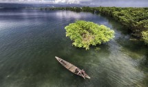
A haor is a wetland ecosystem in the north eastern part of Bangladesh which physically is a bowl or saucer shaped shallow depression, also known as a backswamp. During monsoon haors receive surface runoff water from rivers and canals to become vast stretches of turbulent water.
The total area of haor-type wetland ecosystem in Bangladesh is 80,000 square kilometres. The haor basin is bounded by the hill ranges of India – Meghalaya on the north, Tripura and Mizoram on the south, and Assam and Manipur on the east.
Conservation efforts
Kauadighi Haor is a small one, but extraordinarily beautiful. The word Akashi means sky blue color and the word Haor means inundated water body that is created due to overflowing of nearby river. So, combining the two words it means sky blue colored water body. And interestingly the color of the water was really bluish. The clouds from the sky easily reflect on the pristine water from the Haor.
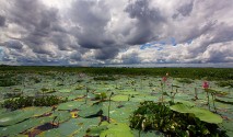
Few places are occupied with water there. So local people usually do fishing, and probably they will continue until the area dried up totally. Most of the fishing nets are having same design and structure. Also, the style of fishing is a bit different from other area as well.
Master Plan of Haor Area
The Bangladesh Haor and Wetland Development Board (BHWDB) has taken the initiative to prepare a comprehensive Master Plan with a view to preserve, protect.